in-canyon view from Ooh-Ah Point click for larger version (84k)
 in-canyon view from Ooh-Ah Point click for larger version (84k) |
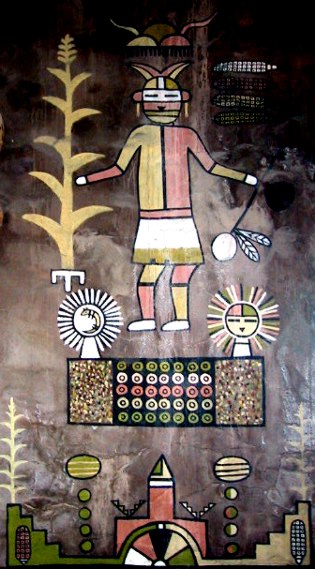
 Hopi motifs at Desert View
At right, in the red circle, a hiker begins the trek down the South Kaibab Trail. He (or she) uses up precisely two pixels in this image, taken from about 500 feet below the rim, or not quite a tenth of the way to the river.
We started our own trek fairly early, hoping for (and getting) quite a bit of shade on the way down. By the time we started back up, the shady spots were shrinking rapidly. |
The South Rim is dryer, lower, hotter, terribly crowded even in May ...but it's easier to get to! So this is where everyone goes. The canyon is still impressive, but not as immediate or animated by light. The focus here is on tourism, the quaintest aspect of which is that prior to tourism, there was life in this dry and difficult place. Indian lore is inextricably tangled with the South Rim experience.
We expected (and got) a much more authentic view of Southwestern culture at Mesa Verde. We were here at the South Rim to walk down into the canyon and feel its immensity from within ...and that's what we did the next day on the South Kaibab Trail.
hiker on the Kaibab switchbacks |
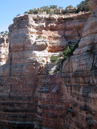
 the upper canyon wall
Watching our footing on the slippery trail, our eyes were nevertheless constantly being drawn down in the abyss, up to the glowing rim, and out across the magnificent canyon. We knew that going down was going to be easier than going up, and so we kept looking back and gaging the distance we'd have to travel to regain the rim. |
Like Zion, the sheer walls are punctuated by hanging gardens. Unlike Zion, they hang on cliffs that tumble a mile down. This would be a great place to be a bumblebee or a cliff swallow. Other, terrestrial life forms live in constant danger of falling a long way. We felt out of place and precarious from the moment we started down into the canyon.
house-sized fallen block |
 two layers meet
Half an hour, more than a mile of trail, and a thousand vertical feet, we came to the mighty red wall, the second great stratum that walls the canyon. By this time, the sounds of the rim have been left behind, and we began to hear (along with the yapping hikers) the hum of the canyon's solitude. |
It's hard not to see geology lessons everywhere in this mighty dissection of earth's crust. The obvious layering reminds us that these top layers were once the bed of a shallow inland seaway, and that sharp color changes mark equally sharp climatic changes in the sea and atmosphere above it.
Redwall -- Rochelle in red circle |
 upriver from Ooh-Ah Point
We had a snack, watched hikers strive by going up and down, gathered our courage for the trek back up, and then, as our little bit of shade kept shrinking, started. On the way up, moving more slowly, it was easier to focus on the details within the grandness -- little plants, rock structure, lizards.
Going up!
photo credit: Rochelle Elkan
Like Zion, the rock here is carved into fascinating shapes by water and wind. The redwall, in particular, has the look of infinitely detailed sculpture.
We could still feel a bit of our over-exertion at Angel's Landing in Zion as we climbed back up, but the trail is gentle and the return isn't as bad as we feared it might be (or as the tourist brochures warned.) Stopping for a sip of water, we took time to memorize the rocks, the views, the grandeur. |
We reached our destination, Ooh-Ah Point, a mile and a half of trail and 780 vertical feet below the rim, where for the first time on the trail we could see back upstream, and get the full sweep of the canyon. (For a good sweep picture, check out the Ooh-Ah pan (84k))
Ooh-Ah Point
Redwall detail |
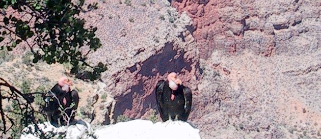
 California Condors |
The canyon wasn't finished dazzling with us. Amidst the Coney Island chaos of Canyon Village, swooping over the rim toward sunset, an enormous bird swooped low over us, and following quickly, we saw his mate settle on an outcrop below us. Moments later, he settled, too, and furled his nine and a half feet of wing.
Their presence changed the focus for many another visitor, who hurried to the edge to look down and tell each other what they were seeing. Seeing these enormous birds flying freely over the canyon somehow emphasizes the regenerative power of nature, seasoned ever so slightly with the knowledge that the Condors' return from the brink of extinction does not tell a complimentary story about humanity. (Condors, at the top of the food chain, bio-accumulate more than most other animals. Human enthusiasm for the "magic bullet" DDT was their nemesis. We barely got stopped in time.) These giants birds may be too gentle to share a planet with humans, but for a brief time, they are making a comeback, and seeing them was, for me, a heart-racing, teary-eyed thrill.
|
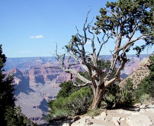
 juniper & canyon at Hermit's Rest |
We rode the bus to the furthest west point on the South Rim, wondering at the 3,000 foot sheer cliff at The Abyss, the river sparkling a mile below us. Again I experienced the difficulty of photographing this big place with my little camera, and was a little glad. The Grand Canyon is a presence that must be seen to be believed.
|
|
|
updated 21 May 2002 : 14:44 Caspar (Pacific) time this site generated with 100% recycled electrons! send website feedback to the Solarnet webster |
© 2001-2002 by Caspar Institute. All Rights Reserved. | |